
Collin County has updated the Collin County Thoroughfare Plan following adoption by the Collin County Commissioner's Court on December 8, 2025. This page contains information regarding the update.
Collin County has experienced rapid population growth in recent decades. Projections show population continuing to increase from approximately 1 million in 2020 to over 2 million by 2050.
Developing a cohesive roadway network and planning for future growth can take years, which is why the thoroughfare plan considers both today's major transportation facilities as well as future planning and development needs.
The update better aligns the county's Thoroughfare Plan with the thoroughfare plans of local cities and adjacent counties, and minimizes, wherever possible, impacts to planned and future developments, existing floodplains, existing property lines, and other environmental factors.
Click the topics below to learn more.
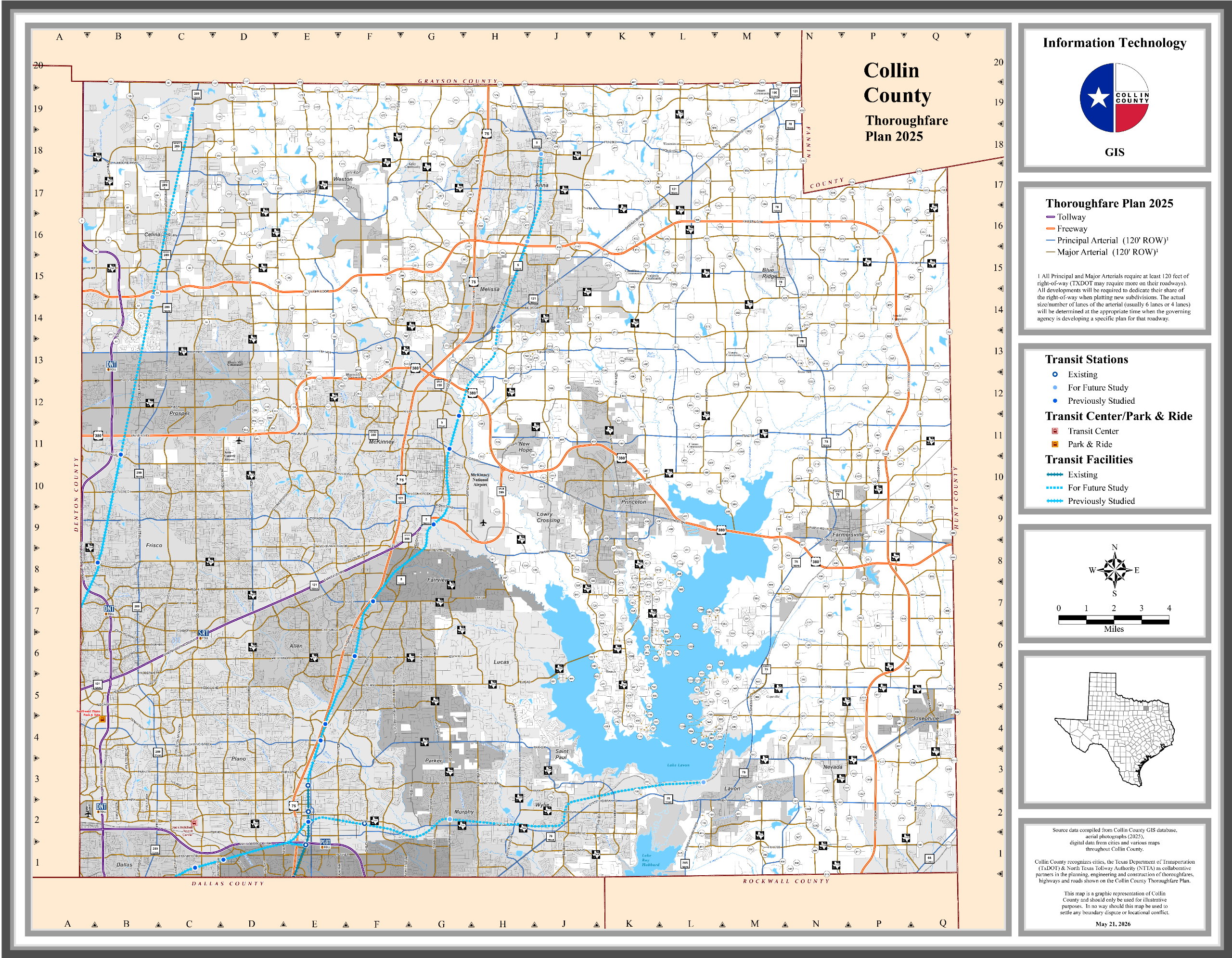
The Collin County Thoroughfare Plan is a long-range planning document used to set a vision for the county's future roadway network. It identifies major thoroughfares - both existing and proposed - and is updated periodically in collaboration with municipalities, adjacent counties, and transportation agencies.
The Thoroughfare Plan identifies the location and type of roadway for all major city, county and state thoroughfares – both existing and proposed – that are part of the future road network.
The Collin County Thoroughfare Plan may include these types of roadways:
Freeways: high-speed, controlled-access roads for long trips.
Principal Arterials: high-capacity roads that provide key linkages between cities and major activity centers, carry intra-regional traffic, and connect traffic from minor arterials to freeways or expressways.
Major Arterials: four- to six-lane roads typically located on a 1-mile grid spacing that provide intra-community continuity and carry local traffic to principal arterials.
The Thoroughfare Plan is NOT a timeline of construction projects. The final alignments for any proposed thoroughfares will be determined during the engineering and design phases for those individual projects.
The Thoroughfare Plan helps local governments prioritize infrastructure investments and manage traffic patterns effectively over time. It also provides guidance for future planning and development and ensures that roads, highways, and streets are appropriately planned to accommodate growth, improve safety, and support economic development.
Collin County typically updates the county’s Thoroughfare Plan every 5-10 years in coordination with municipalities, adjacent counties, and TxDOT to ensure a well-organized transportation system. The Collin County Thoroughfare Plan was previously updated in 2014 and 2020.
The County’s Thoroughfare Plan does not address the construction schedule for roadway projects. Rather it identifies existing thoroughfares and the general alignments for the extensions of existing arterial roadways and planned new roadways. Many of the identified arterials will likely not be needed or constructed within the next 10-20 years. Final route alignment and design for each of the identified roadways will be determined during the final engineering and construction process for those individual projects.
Collin County held Public Information Sessions in Spring 2025 to gather public input on proposed changes to the Thoroughfare Plan. The County carefully reviewed nearly 500 comments received during the public comment period and has revised the proposed Thoroughfare Plan for consideration by the Commissioners Court.
During the public comment period held in Spring 2025, Collin County received nearly 500 comments on the proposed Thoroughfare Plan update. These comments were carefully reviewed, and the proposed Thoroughfare Plan was adjusted where possible. Below are some of the changes that were made to the proposed update to the Thoroughfare Plan.
(Please note, this is not a comprehensive list of all adjustments made. Please refer to the provided maps to see the latest proposed update to the Thoroughfare Plan and the currently adopted 2020 Thoroughfare Plan.)
- Collin County Outer Loop Seg. 2 and 4 Alignment – Segments 2 and 4 of the Collin County Outer Loop have been updated to reflect the new Preferred Alignment identified by Collin County as part of an ongoing project to develop the schematic design and Local Environmental Document for that project.
- Collin County Outer Loop Seg. 2 and 4 Alignment Adjacent Arterials – Proposed arterials have been removed in areas where the updated Collin County Outer Loop Segments 2 and 4 alignment has shifted. Changes include:
- The removal of a proposed north-south major arterial along CR 939 and CR 595 near Nevada.
- The removal of a proposed arterial along CR 591 extending south to CR 588.
- The removal of a proposed arterial connecting CR 590 to CR 588 along Private Rd. 5377.
- FM 1138 – A proposed major arterial along FM 1138 south of Nevada has been added back to the Thoroughfare Plan due to the change in the Collin County Outer Loop Alignment.
- FM 455 southeast of Weston – The proposed alignment of FM 455 southeast of Weston has been adjusted to reduce potential residential and property impacts. The future alignment of FM 455 will be determined by TxDOT.
- FM 544 at Sheffield Dr. – The proposed alignment of FM 544 east of Anna at Sheffield Dr. was adjusted to reduce potential residential and property impacts. The future alignment of FM 455 will be determined by TxDOT.
Anna:
- Ferguson Pkwy – The alignment of the proposed extension of Ferguson Pkwy to Collin County Outer Loop was adjusted to align to TxDOT plans.
- Rosamond Dr. – The alignment of CR 370/Rosamond Dr. west of US 75 was adjusted to follow newly constructed roadway.
Farmersville:
- SH 78 in Farmersville – The proposed future alignment for BUS SH 78 in Farmersville was shifted back to the existing SH 78 alignment.
Lavon:
- FM 2755/CR 483 – The alignment for the proposed extension of an arterial from FM 2755 to CR 483 near Lavon has been adjusted to align with the City of Lavon Thoroughfare Plan and the proposed Nicholson Ranch Development plans.
- Skyview Ln – A proposed north-south arterial near Skyview Ln. has been adjusted to align with the City of Lavon's Thoroughfare Plan and reduce impacts to the Skyview Ln. neighborhood.
Lucas:
- Forest Grove Rd. – The proposed east-west arterial along Forrest Grove Rd. in Lucas has been removed from Country Club Rd. to Orr Rd.
- Orr Rd./Winningkoff Rd. – The proposed alignment for a future thoroughfare along Orr Rd. has been adjusted to reduce potential residential and property impacts but is still proposed to connect to Winningkoff Rd.
McKinney:
- FM 2933 to SH 5 – The alignment for the proposed extension of FM 2933 to SH 5 was adjusted to follow existing CR 339 to reduce potential residential and property impacts.
Melissa:
- CR 362 to CR 1217 – The alignment for the proposed extension of CR 362 from CR 340 to CR 1217 was adjusted to avoid potential residential impacts.
- CR 409 – The alignment for the proposed extension of CR 409 from CR 412 to CR 413 was adjusted to avoid potential residential impacts.
Collin County:
- FM 2862 at Wolf Run Creek – The proposed alignment of FM 2862 at Wolf Run Creek has been adjusted to reduce potential residential and property impacts.
- CR 206/Chambersville Rd. – The alignment for the proposed extension of CR 206/Chambersville Rd. to CR 363/Ridgeview Rd. has been adjusted to reduce potential residential and property impacts.
- CR 281 at the Collin County Outer Loop – The alignment for the proposed extension of CR 281 north of the Collin County Outer Loop has been adjusted to reduce potential residential and property impacts.
- CR 479/CR477/Sheffield Dr. – The entire proposed north-south arterial from FM 3133 to the Collin County Outer Loop, roughly following CR 479 to CR 477 to Sheffield Dr. has been removed.
- CR 494 – The alignment of the proposed extension of CR 494 was adjusted to reduce potential residential impacts.
- CR 563/CR 496/FM 2756 – The proposed extension of CR 563 to CR 496 and the proposed extension of FM 2756 south to CR 563 were both removed. A proposed major arterial was added along the existing CR 559 alignment from US 380 to CR 561, then following the CR 561 alignment to CR 469.
- CR 1104 – The proposed extension of CR 1104 from CR 1103 to CR 178 as adjusted to avoid a potential residential impact.
Proposed Thoroughfare Plan Update
Place your cursor over the <>icon, then click and drag to the right to view the current 2020 Thoroughfare Plan or to the left to reveal the proposed 2025 Thoroughfare Plan.

-
 Adopted 2025 Collin County Thoroughfare PlanPDF (9.47 MB)
 -
2025 - Collin County Thoroughfare Plan FactsheetPDF (149.75 KB)
-
2025 - Collin County Thoroughfare Plan FAQPDF (136.21 KB)
-
2025 - Public Information Session Exhibit BoardsPDF (1.81 MB)
-
Previous 2020 Collin County Thoroughfare PlanPDF (2.01 MB)


